The Howard Smith Wharves have been investigated initially and somewhat superficially in the previous post, however, it is also important to view them from an architectural perspective and assess them in regards to potential opportunities and restrictions they may present. Key aspects such as the context, accessibility, nearby services, potential restrictions and potential opportunities are discussed and explained in this post.
CONTEXT
The Howard Smith Wharves are located along the Brisbane river bank in the suburb of Fortitude Valley. They are located a short distance from the Central business district and can be accessed from nearly all directions and by various means of transport, both public and private. The area towards the West of the Wharves is dominated by residential buildings including houses and apartment buildings. Smaller commercial and retail buildings can be found within Fortitude Valley while larger, high rise office buildings and apartment blocks dominate the Eagle Street Waterfront and the CBD, to the East of the Wharves. This surrounding area is highly populated and used and as a result there are a lot of potential users in close proximity to the site. The riverfront walkway is often busy with people exercising and it is a popular route for runners, cyclists and walkers.
 |
| Macro Scale View of the site- Image- Nearmap |
 |
| Residential zone in yellow, Commercial/Mixed use high density area shown in blue. Image- Nearmap |
ACCESS
Vehicular access to the site is granted via Boundary Street, a small service road that connects Ann Street and Ivory Street. Pedestrian access is currently prohibited, however, it can be assumed that the walkway that was damaged and destroyed during the 2011 floods, still exists, and runs along the waterfront. There are also pedestrian and bicycle paths that run along the top of the site, adjacent to Bowen Terrace and these grant access to the pedestrian paths atop the Story Bridge. There are also multiple public transport options within close proximity to the site, including buses, city cat services and a city cycle station.
 |
| Vehicular access point to the site highlighted in red. Image- Nearmap |
SERVICES
Due to the site's location and its close proximity to the CBD, it has easy access to a number of services. Although vehicular access to the site is somewhat restricted, it is still sufficient for emergency services, supply vehicles and other similar activities. There is also an abundance of public transport around the site, making access to it very easy and minimising the need to parking spaces on the site itself, although there is adequate space for this on the site. The spaces around the site such as the Eagle street boardwalk are often used as exercise paths and provide a vital function within the CBD.
| Various Transport. Citycat in red, major bus stops in yellow and train stations in green. |
RESTRICTIONS
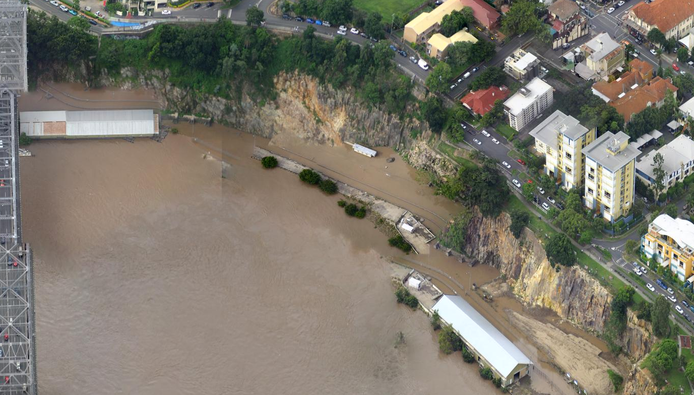
One of the most important aspects to consider is the possibility of the site flooding, as it did in 2011. This should be considered during the design process and it may be favourable to construct the interaction node out of a durable material that won't be damaged if submerged. This is also worth considering when selecting an activity for the node. Another restriction, although not as obvious is access to the site. The service road provides vehicular access, although it may not be capable of sustaining a high amount of traffic. Pedestrian access is currently non existent, although it can be used that the Eagle Street boardwalk continues along the length of the site and this would provide adequate pedestrian access to space.
The final restriction would have to be the existing structures and the manner in which they dominate the existing space.It is integral for the interaction node to communicate effectively with these structures as well as the greater site, and as the structures are heritage listed, any modifications to them, may not be possible.
The final restriction would have to be the existing structures and the manner in which they dominate the existing space.It is integral for the interaction node to communicate effectively with these structures as well as the greater site, and as the structures are heritage listed, any modifications to them, may not be possible.

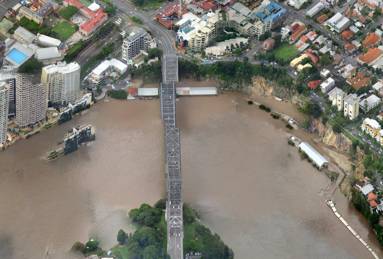 |
| Various Images taken during the 2011 floods. Image- Nearmap |
OPPORTUNITIES
The site as a whole provides a number of great opportunities to activate and bring attention to an unused and historical site within the inner city. The Wharves were an important site in the development of the city, and bringing attention to them and educating people about this could be seen as very desirable. Currently, the site is a very large block of unused space within the CBD which is not very common. Activating this space could provide the city with another vibrant attraction and assist in reinforcing Brisbane's claim to be a new world city. The size and location of the site are key factors in this and the abundance of potential users in close proximity to the site are another factor that can greatly contribute to the effectiveness of the interaction node.
Creating a link between existing green spaces could be vital to the development of the site.
POSSIBLE NODE LOCATIONS
The immense size of the site and relatively small size of the interaction node means that it can be placed nearly anywhere. However, depending on the chosen activity, some locations may be more effective than others. For example if the node is focused around exercising, a location close to the riverfront and the boardwalk may be desirable, while if it were something more unique and unspecific to anything within the site, it could be located along the cliff face, with a possible staircase proving easy access from above. A possible integration into the existing structures, may also provide an interesting and eye catching result.
The site as a whole provides a number of great opportunities to activate and bring attention to an unused and historical site within the inner city. The Wharves were an important site in the development of the city, and bringing attention to them and educating people about this could be seen as very desirable. Currently, the site is a very large block of unused space within the CBD which is not very common. Activating this space could provide the city with another vibrant attraction and assist in reinforcing Brisbane's claim to be a new world city. The size and location of the site are key factors in this and the abundance of potential users in close proximity to the site are another factor that can greatly contribute to the effectiveness of the interaction node.
Creating a link between existing green spaces could be vital to the development of the site.
 |
| Various existing green park spaces. Image- Nearmap |
POSSIBLE NODE LOCATIONS
The immense size of the site and relatively small size of the interaction node means that it can be placed nearly anywhere. However, depending on the chosen activity, some locations may be more effective than others. For example if the node is focused around exercising, a location close to the riverfront and the boardwalk may be desirable, while if it were something more unique and unspecific to anything within the site, it could be located along the cliff face, with a possible staircase proving easy access from above. A possible integration into the existing structures, may also provide an interesting and eye catching result.
 |
| Potential locations for the interaction node. Image- Nearmap |
No comments:
Post a Comment